Black Mountains Archaeology - Archaeoleg Mynydd Du
Providing archaeological and aerial mapping services to the public and private sectors

Recent Surveys
Clyne Valley Shaft Mounds, Swansea
We were commissioned by City and County of Swansea to carry out an archaeological survey of damage caused to the Scheduled Ancient Monument of Clyne Valley Shaft Mounds (SAMGm455) by mountain bike (MTB) enthusiasts creating a network of downhill tracks, ramps and jumps inside the scheduled area.

Multiple drone flights using standard RGB, thermal and multispectral cameras were carried out to produce a detailed 3D photogrammetric record of the survey area. A total of ten 16th century bell pits were identified together with three large spoil mounds on broadly a N-S alignment and up to at least another nine smaller mounds or historic spoil areas but identification of these features was hampered by the bracken cover. A total of eleven full or partial downhill MTB tracks were recorded, many obscured by vegetation cover. Multiple drone flights using standard RGB, thermal and multispectral cameras were carried out to produce a detailed 3D photogrammetric and topographic record of the survey area.

The use of a diverse range of data capture, RGB, multispectral and thermal, was critical in revealing those MTB tracks and excavations hidden by vegetation. The bell pits and spoil mounds appear to be largely intact, but some evidence of unlawful excavations on the site. These are mainly shallow tracks with embanked corners that utilise the large bell pit spoil mounds as ramps and jumps.

St David’s Hall, Cardiff
Together with our friends at ArchaeoDomus, we were commissioned by Taliesin Conservation on behalf of Cardiff Council to undertake a photogrammetric rooftop survey of the mansard roof on St David’s Hall, Cardiff. The aim of the survey was to produce accurate, measured 3D photogrammetric modelling of the mansard roof utilising aerial (drone) digital cameras followed by the drafting of detailed plans and elevations in CAD.
St David’s Hall is the National Concert Hall and Conference Centre of Wales and was designed by architects Seymore Harris Partnership, and opened in the autumn of 1982.

The survey was undertaken with high resolution camera equipped UAVs (drones). The 3D photogrammetric model was produced using proprietary photogrammetry software and aligned using known ground control points (GCPs), which were tied into the Ordnance Survey National Grid and Datum using an RTK GNSS/Glonass (GPS) Receiver. The resulting Ground Sampling Distance (GSD) achieved 0.97cm/pixel. The 3D model produced a dense point cloud of over 92 million points and a high face count mesh with a mean RMS error of 0.13cm.
The primary purpose of the survey was to record the condition of the lead mansard roof in detail. Consequently, no attempt was made to survey the lower elevations in any detail. A high resolution 3D model was provided to the client together with a version uploaded to a bespoke interactive, measurable and sharable 3D platform. The final 3D model was very large and detailed so we reduced the size of the model (<300mb) to enable upload to a 3D model sharing website (above) for broader public accessibility.

We then produced series of high resolution measured orthographic plans and elevations from the 3D photogrammetric survey to inform on the conservation efforts for the mansard roof.

Former Tyla Cartshed, Gilwern Hill

Melin Mynach, a Medieval and Post-medieval Mill

We were recently asked by Swansea Council and Mann Williams Civil Engineers to undertake a 3D photogrammetric survey of the Melin Mynach Scheduled Monument (SMGm501), a former mill site in Gorseinon, to inform on conservation management plans.
The site broadly consists of the remains of a medieval and Post-medieval gristmill, an early Post-medieval paper mill and later woollen mill. Cadw note that “…water power has been used at this location for a number of industrial purposes for a long period [of time]. The earliest mill is thought to be of monastic origin, possibly built after Neath Abbey took over the estate of Cwrt-y-carnau in 1150, and was probably a corn mill. The first documentary reference to a mill was in 1578. In 1772 it was converted for paper making, and was one of the first of its kind in Wales, in use for over a century. It was returned to use as a corn mill in the 1830’s, but in 1866 William Lewis converted the mill to woollen manufacture, enlarging it substantially in 1874. From 1888 the site was turned to chemical and tinplate manufacturing, and the mill itself became disused. The main surviving features are the leat, pond, paper mill, woollen mill, two wheel pits, dye-houses and the mill owner’s house” (Cadw). Read a bit more about the history of the site on our blog.
The survey was undertaken with a high resolution camera equipped UAV (drone) and DSLR camera. The 3D photogrammetric model was produced using proprietary photogrammetry software and aligned using known ground control points (GCPs), which were tied into the Ordnance Survey National Grid and Datum using an RTK GNSS/Glonass (GPS) Receiver. The resulting Ground Sampling Distance (GSD) achieved 0.83cm/pixel. The 3D model produced a dense point cloud of over 171 million points and a high face count mesh (>34m), with a mean RMS error of 6mm. You can view a copy of the 3D photogrammetric model below that has been reduced in size/detail. The finished 3D model was so large (and detailed) we had to reduce it by around 70% to allow us to share online.
We then produced series of high resolution measured orthographic plans and elevations to inform on the conservation efforts.


Tintern Abbey
We are pleased to be able to share some of our recent work in Monmouthshire. We were asked by Cadw to undertake a photogrammetric survey at Tintern Abbey (SAMMm102). The aim of the survey was to produce accurate, measured 3D photogrammetric modelling of the east wall of the Chapter House and east facing elevation of the Monk’s Dortor/Day Room. The survey areas were situated adjacent (east) to the mid-12th century cloister and formed part of challenging restoration work being carried out by IBEX Technical Access LTD. We also had time to take a quick drone video during lunch, you can view the video here.


Alina’s Chapel, Oystermouth Castle
We were recently asked by Taliesin Conservation to undertake a high resolution, metrically accurate 3D photogrammetric survey of Alina’s Chapel, Oystermouth Castle (SAMGm007) to produce a ‘Digital Twin’ ahead of conservation work. The survey was undertaken with a camera equipped UAV (drone) and tied into the Ordnance Survey National Grid and Datum using an RTK GN55/ Glonass (GPS) Receiver. The survey generated a dense point cloud over 97 million points with a mean RMS error of 0.013m. Six GCPs were used and surveyed with an GNSS/ Glonass (GPS) Receiver and data logger with a sub-20mm error margin to OSGB36 (National Grid). The Ground Sampling Distance (GSD) achieved was a great 0.84cm/pixel.
You can view the 3D photogrammetric survey of Alina’s Chapel here. A high resolution still from the 3D model is below.

Neath Castle

We were asked by Neath Town Council through their agents Hurley & Davies to carry out a building record of a partially collapsing Post-medieval wall located perpendicular to the north curtain wall of Neath Castle. We created a 3D photogrammetric model of the collapsing wall and then carried out an archaeological watching brief during the renovation of the wall. During the course of the watching brief part of the medieval NE Tower was discovered hidden behind the partially collapsing Post-medieval wall.
The detailed 3D model of the Post-medieval wall before renovation can be viewed here https://p3d.in/f380u.
Scaffolding supporting the wall was removed in the point cloud to gain a better view of the wall and its phasing. Some ‘ghosting’ of the removed scaffolding can be seen in the 3D mesh. The dense point cloud generated over 55 million points with a mean RMS error of 0.012m. Five GCPs were used and surveyed with an EMLID Reach GN55/ Glonass (GPS) Receiver and data logger with a sub-20mm error margin to OSGB36 (National Grid). The Ground Sampling Distance achieved a great 0.31cm/pixel.
Part of the medieval NE Tower was discovered hidden behind the partially collapsing Post-medieval wall. We created a detailed 3D photogrammetric model of the medieval discovery, which can be viewed here https://p3d.in/dw4It. The dense point cloud generated over 15 million points with a mean RMS error of 0.006m. The Ground Sampling Distance (GSD) achieved was a great 0.301cm/pixel.
Special thanks to Cadw, Neath Town Council, Hurley & Davies and Taliesin Conservation.
St George’s University Hospital NHS Foundation Trust, London

Together with ArchaeoDomus we were recently asked by iDEA LTD to produce a high resolution 3D photogrammetric survey of St George’s University Hospital NHS Foundation Trust. The project was particularly challenging given the survey area extended to 96 acres over one of the busiest hospitals in the UK. The 3D model we produced had a dense point cloud of over 151 million points and a fantastic Ground Sampling Distance of 1.7cm. Five GCPs were used and surveyed with an GNSS/Glonass (GPS) Receiver and data logger with a sub-20mm error margin to OSGB36 (National Grid).
Usk Castle, Monmouthshire
We recently recorded the Outer Curtain Wall, Dovecote and South Towers at Usk Castle. Both terrestrial and aerial cameras were used including three drone flights. The dense point cloud generated over 50 million points with a mean RMS error of 0.016m. Seven GCPs were used and surveyed with a GNSS/ Glonass (GPS) Receiver and data logger with a sub-20mm error margin to OSGB36 (National Grid). The Ground Sampling Distance (GSD) achieved was a great 0.316cm/pixel. Outputs include a 3D point cloud and mesh, high resolution orthomosaic and animation.


Hafod-Morfa Copperworks, Swansea
We are currently working at the incredible Hafod-Morfa Copperworks, Swansea. We are excavating part of the site in advance of the refurbishment of the former Morfa Powerhouse and later Yorkshire Imperial Metals canteen (LB 11691) building into a distillery and visitor centre by Penderyn Whisky (our favourite whiskey!). We have undertaken comprehensive surveys of the site including centimetre accurate 3D models. You can view a 3D model below of the recently excavated bathhouse at the Hafod-Morfa Copperworks together with other 3D surveys on the site here and below.

Fly through animation of the Powerhouse and Foundry, Hafod-Morfa Copperworks.
Prehistoric funerary site near Llanmaes, Vale of Glamorgan
In 2019 we investigated a major Bronze Age burial site, the ploughed out remains of a large (c40m diameter) earthen round barrow similar to those known at Sutton (GGAT HER 00285s), Sheeplays (GGAT HER 00287s and 00288s) and Six Wells (GGAT HER 00289s and 00290s) a few miles to the north. At least three satellite cairns (carbon dated to Middle Bronze Age) were placed around the round barrow and a large cremation cemetery was found to the south west of the round barrow containing over 50 cremations. A possible Bronze Age field system was discovered, identified by four sets of double post-holes and two single post-holes. An Early-medieval corn (grain) drying oven was recorded and radiocarbon dated to 660-770 cal AD. The oven was recorded using terrestrial photography to create a 3D photogrammetric record of the discovery. You can view the corn drying oven 3D model below.

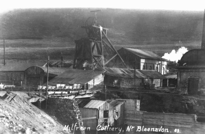
Milfraen Colliery, Torfaen
Milfraen Colliery (NPRN91596) and Cottages (NPRN67584) landscape survey. The former colliery lies within the Blaenavon World Heritage Site.

Milfraen Colliery was opened in around 1834 and a new shaft was sunk in 1865 by John Jayne (Jayne & Co.). It was taken over by the Blaenavon Iron & Steel Co in 1884 and the last coal lifted in 1933 when it was then primarily used as a ventilation shaft. The colliery finally closed in 1950. On the 4th March 1902 five men fell to their deaths in a lift shaft accident and later on 10th July 1929 nine men lost their lives in a below ground gas explosion.
Gallery


